Contact Us
By email:
info@one-place-studies.org
By post:
Society for One-Place Studies,
7 Edge Lane,
Rossendale,
Lancashire
BB4 7SS
United Kingdom
Chesham Bois is an ancient parish but, until the early 1900s, was mainly a rural area sandwiched between Chesham and Amersham. It grew massively in the 20th Century – primarily due to the way this part of South Buckinghamshire became part of “Metroland” with the growth of the London Underground system. Nowadays it blends quite closely with Amersham-on-the-Hill which has also developed in a similar way in the same timescales.
My One Place Study is mainly focused on the growth of the area post-1900 and is primarily used to identify when streets and roads in the parish first appeared and when the individual properties were built and the various house names they were known by. It started with curiosity about the growth of my own and adjacent streets which were built on farmland sold off in 1906 but my research then expanded to cover the whole of Chesham Bois parish. The majority of the early housing were one-off buildings (often designed by renowned local architects) and it was only in the 1950s-onwards that the few “estates” of houses were speculatively built for sale.
I have created a plot of every individually-named property (including any house-name change) and the year it is mentioned. This often involved cross-referencing the different sources to get the most correct information.
Other researchers have worked on the earlier history of the parish (see References below).
Although not registered as a separate One Place Study, I have started to record similar data on the adjacent parish of Amersham-on-the-Hill.
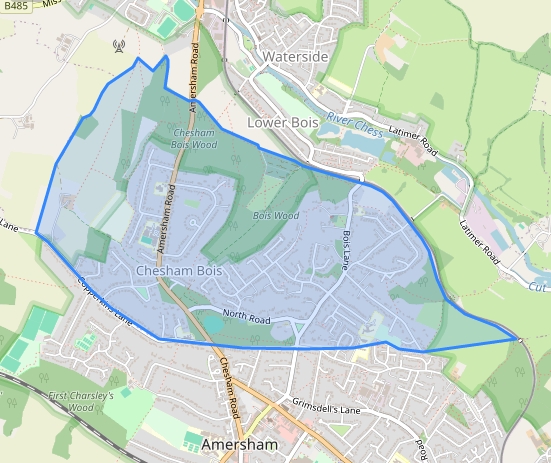
Chesham Bois is in South Buckinghamshire and is located to the North West of Greater London. The adjacent parishes of Amersham and Chesham both have Underground stations at the extremity of the London Underground tube network.
Chesham Bois initially had the River Chess as its northern boundary and included some of the water-cress beds and a lot of the terraced housing built for the railway workers. However, in 1934 the area around The Moor and between the River Chess and the Railway was transferred to the Chesham Urban District Council.
Census
Electoral Register Entries
The main scope of my One Place Study is about the growth of Chesham Bois in the 20th Century driven by the arrival of the rail links to London.
The earlier history of Chesham Bois can be found in the other sites mentioned in the References section below.
Prior to the 1900s it was a typical rural economy but the arrival of the railways resulted in almost all the original farm land being sold off for housing. It is now a mainly residential area with few commercial activities but there are several private schools to meet the requirements of this and adjacent affluent areas.
The main Church of England parish church is St Leonards which was originally built as a small chapel in the 13th & 14th Century with extra parts added in the 17th & 18th centuries. The Catholic church was built in the early 20th century to meet the needs of the growing local population.
Chesham Bois has the usual mixture of social activities of any largely-residential area. There are only a few shops within the parish boundary but the area is well-served by the facilities of both Amersham and Chesham.
In the early 1900s there was a small “artistic” community in the area.
Chesham Bois does not have an obvious “village centre”.
Pubs:- There are no public houses currently located in the parish boundaries although there were some in the part that transferred to Chesham in the 1930s.
Schools:- There are several public and private schools in the area – the private schools also catering for families from nearby towns and villages. I also have the Chesham Bois Church of England School Committee Minute Books and Admission Registers 1900-1967.
The area is mainly residential and provides housing for commuters into London who have moved out of the more congested suburbs of London or have moved from other parts of the UK for employment in the capital.
As I have transcribed all the electoral registers and other source records, I can easily do a name search for any individual who is listed as a resident in any of the original documents. I have started to build family trees for individuals who have resided in the area for longer periods of time.
Other local researchers have produced information about the earlier history of Chesham Bois so I have not tried to re-do this research but have focused on post-1900 growth.
The Amersham Museum website also contains several articles covering the people and places of Chesham Bois.
Chesham Bois History:- https://www.genuki.org.uk/big/eng/BKM/CheshamBois
Amersham Museum:- http://www.amershammuseum.org/
Chesham Bois within Amersham Museum website:- https://amershammuseum.org/history/chesham-bois/
The following source records have been transcribed to extract the names of residents and their addresses where provided:-
In addition to the above I also accessed Planning Applications as these usually have detailed site plans giving names of the adjacent properties.
The author of this work retains all rights and must be credited when the material is displayed or shared. Any use of the material for commercial purposes requires the written consent of the author, as does any use of a significant portion of the material for purposes other than individual private research.
By email:
info@one-place-studies.org
By post:
Society for One-Place Studies,
7 Edge Lane,
Rossendale,
Lancashire
BB4 7SS
United Kingdom
© The Society for One-Place Studies