Contact Us
By email:
info@one-place-studies.org
By post:
Society for One-Place Studies,
28 St Ronan’s Avenue,
Southsea, Hampshire, PO4 0QE
United Kingdom
Contact: Joe Saunders
Before the advent of railways, no main road going through the place, it was very secluded, and had little intercourse with the outer world. Although there is no castle or manorial hall at Crosby to attract antiquarians, still there are many objects and incidents connected therewith which may be of interest to some people.
Nicholson, Crosby Garrett (1914), 8
Crosby Garrett is a parish in the east of the county of Cumbria, in the Upper Eden Valley. Historically part of the county of Westmorland it is an area that has long been seen as at the fringes of England. Crosby is an ordinary place which is known in the wider world for a Roman Cavalry helmet found by metal detectorists in 2010. Aside from this it is an otherwise unremarkable place, filled with common people and where no major events have ever occurred. It is, however, much more. Local history is not small history. Within the village major events and themes in English history can be viewed up close. This study aims to reveal an interesting social history of the community over time.
In addition to the Roman helmet, there are notable prehistoric sites in the parish which mark it as historically significant. There is a wealth of physical remains in Crosby which survive into the present day, including a church with Saxon fabric, tithe barns, rigg-and-furrow marks, clapper bridges and houses dating back to the seventeenth century. The village has long had a strong nonconformist population (Baptist and Methodist) and is notable for the Settle-Carlisle railway which runs through it. From a documentary perspective the community can be traced with some confidence from the late sixteenth century onwards from which point parish registers and probate material exists. From the seventeenth century good runs of manorial documents, churchwardens accounts and other material enables a close study.
This report represents a short summary of known information and more detail is available on request to anyone else carrying out family or local history research. I plan to use this study to focus my community history research which I hope one day to share with the current community. I would warmly welcome any information anyone may have which could be of use.
Crosby Garrett is a parish in the Upper Eden Valley. It was formerly in the county of Westmorland, which is now part of Cumbria, the north-westernmost part of England. The parish itself is large and rural, like many in this part of the world, mostly consisting of farmland. A considerable part of the parish consists of high-lying grass fell on limestone to the south of the village.
The village itself lies a little under 700 feet above sea level though the parish reaches 1198 feet at Great Ewe Fell and 1254 feet at Nettle Hill, the highest point of the parish. The area of enclosed land in 1914 was 2,017 acres, while the fell, a regulated common, was about 1,200 acres.
The largest settlement is the small village of the same name which has developed in and around a post-glacial hollow. Its most prominent features are St Andrews medieval church high on a hill at the head of the village and the Settle-Carlisle railway viaduct which carries the line across the opposite end of the village.
Crosby Garrett has always been a small community with inhabitants counted at around two hundred persons. While most people in the parish live within the village of the same name others have lived further afield in the hamlet of Little Musgrave, which is in a non-contiguous part of the parish, as well as houses at and near Crosby Garrett Mill and at Potts Beck. The population more than doubled in the early 1870s when the Settle-Carlisle railway line was built to the south-west of the village and the parish became home to many navvies and their families. Many incomers lived within the village and a shanty town was also constructed on the fellside.
The earliest population estimates we have between the 1560s and 1690s give between 150-250 people in the parish. In the first half of the nineteenth century the population was around 250-300 before ballooning to nearly 600 in the 1871 Census. From 1881 the population had fallen dramatically close to former levels and continued to slowly decline over the following century with a low point in 1961 at 136.
No major historical events have occurred in Crosby Garrett, though there have been many events of meaning which have occurred within the community.
Late Neolithic/ Bronze Age
Construction of a series of burial cairns as part of a funerary landscape across what is now Crosby Garrett Fell and surrounding fields, in the southern part of the parish. Notably including Rayseat Pike.
Iron Age/ Romano-British
Remains of three linked ‘camps’ of buildings and field systems near Crosby Garrett Fell in fields known as ‘Intake’ and ‘Severals’ show a period of settlement by pastoral and possibly arable farmers.
Late 1st millennium
A Roman presence in Crosby is known by the discovery of a cavalryman’s helmet in the parish- Late Romano-British
Arrival of Saxon and Norse settlers who likely established a village on the present-day site. Some pagan worship is said to have occurred on Arklow Hill which is along the ridge from Church Hill where the Saxons built a simple place of Christian worship, St Andrews church.
c.1100
The region is under control of the kingdoms of Rheged and Strathclyde before being brought into the Norman kingdom of England in the twelfth century. Crosby is just outside the jurisdiction of Domesday Book. The name Crosby, meaning settlement by the cross, which is common in the north-west of England, is given the suffix ‘Garrett’, likely from the Norman name Gerard. This Gerard was an early person of importance, perhaps a first Norman lord of the manor of Crosby Garrett.
Late medieval
Crosby Garrett manor is held by the Soulby and then Musgrave families throughout the late medieval period. The latter likely inherit by marriage. They possess several manors and become important regional figures. As the lord of the manor did not live at Crosby, except perhaps in the earliest period, there is no knowledge of where the manor house was. Extensive extensions are made to St Andrews church at this time, incorporating some earlier fabric.
Sixteenth century
Following the Reformation the church is said to have been given a slate roof, replacing an earlier thatch once. The first parish records are kept and the earliest surviving wills are also from the reign of Elizabeth I
Seventeenth century
The tenants of Crosby Garrett and other manors are involved in a substantial dispute with the Musgrave lords of the manor relating to their rights. Two churchmen are successively ejected during the period of the civil wars in the middle of the century. At the end of the century local individuals are associated with events of the nearby Kaber Rigg Plot-
Eighteenth century
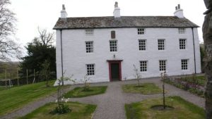
Crosby manor comes into the possession of the Bird family who are also rectors for much of the rest of the century and into the 1800s. Nonconformity is strongly established in the village already with Baptists using first Mossgill House and then a chapel annexed to the house and around a fifth the population by 1777 are dissenters. Several other substantial houses were built, and survive, from this time.
Nineteenth century
Crosby Garrett Fell is enclosed. The construction of the Settle-Carlisle railway which runs through the parish bring work and workers into the area during 1870s. The station at Crosby Garrett changes the nature of life in the village. Methodists are established in the village. The last of the ancient manorial services are ended, much later than elsewhere.
Twentieth century
The World Wars and economic and cultural changes of the early 1900s bring huge change to Crosby Garrett. Mechanisation increasingly changes farming life. The closure of the station in the 1950s heralds an economic and population decline. In later decades Crosby begins to attract tourists.
The area is rural upland or ‘Rough Fell’ with much of the local economic historically, and presently, based around farming. For centuries this has been predominantly pastoral though there is evidence of arable farming before modern times. The only industry of significance in the parish was related to the railway which flourished from around 1870-1950. This attracted a large number of workers and provided employment within the village.
St Andrew’s church sits atop a hill overlooking the village. Parts are Saxon though most of the present building dates from the twelfth century onwards. It is in the present-day Church of England. Notable figures include Edmund Mauleverer who was instituted rector in the 1630s before being ejected by Parliamentary Commissioners in 1645 during the civil wars. The living was taken by the Independent Christopher Jackson. Following the Restoration in 1660 Mauleverer was re-installed. Between the 1710s and 1830s the Bird family held both the manor and the living and several members of this family were rector.
It is said by local tradition that Baptists have worshiped in Crosby Garrett since at least the 1650s at Mossgill House where a chapel was later built for them. In Nicolson and Burn’s History of Westmorland, published in 1777, there were apparently nine Dissenting families in Crosby Garrett.
Methodists have worshipped in Crosby since at least the middle of the nineteenth century. A Wesleyan chapel was built in 1882 on land formerly used by the Settle-Carlisle railway as a yard and to this day is painted in their livery. It is now the place of worship for the United Baptists and Methodists.
Crosby Garrett has always been a very small community with all the pleasures and pitfalls associated. Historically it is said that the parish celebrated the feast of St Andrew, to whom their church is dedicated. In the twentieth and twenty-first centuries the community gathers for regular events such as to celebrate harvest, Christian religious festivals, royal occasions and other gatherings. Many of these consist of eating in the village hall though also include sports, especially quoits. Such events predominate over the winter months. It is likely this is all a continuation of older gatherings. Two modern summer events have developed in recent decades. The Open Gardens and the Hootabilly, an evening music festival. It appears there has never been a market or fair with the nearby town of Kirkby Stephen providing an economic focal point for the small villages in the area.
Many of the present-day inhabitants are descended from people who lived in the village for several generations. Most, if not all of these, have an association with farming families even if they are not themselves amongst the few farmers now working. A large number of people of working age and some retirees have moved to the village within the present generation, often from outside the immediate area. There is little reason to move to the village for work and indeed the lack of work, and shortage of housing, is an incentive for younger people to move away. A large minority of houses are owned as holiday homes for personal and commercial use and so a proportion of the buildings are empty for much of the year. The village is a relatively popular destination for holidaymakers, especially for walkers and cyclists who pass through on one of the roads or footpaths which run into the village.
There was money given in wills for a school at Crosby Garrett from the late sixteenth century onwards, suggesting that until at least this point there was not one. From at least the seventeenth century there was a small school in the village which existed on multiple sites over the centuries. The last school, constructed in the late nineteenth century, was closed and later bought by the community for use as a village hall, replacing an earlier tin-roofed hall. This has long been a focal point for community life.
There have been several religious institutions in the village, discussed above.
Aside from several farms which have been in the same family for many generations, one enduring business of note is Handley’s, a road freight business which runs out of a yard in the village. It was established in the middle of the twentieth century by Thomas Handley who delivered coal out of a wheelbarrow and is still family-run.
The most notable landmark in the village is the viaduct which crosses its southern end, carrying the Settle-Carlisle railway high above the houses below. Within the wider parish Crosby Garrett Fell is a significant natural landmark which rises to 1254 feet above sea level at Nettle Hill.
There are three roads or lanes leading into the village leading north-west, north-east and south-east. To the south-west of the village is the Fell over which several tracks lead. The three roads have likely been the same going back hundreds of years as the presence of three corresponding ‘plague stones’ for washing money attest. The construction of the Settle-Carlisle railway and a station in the village in the 1870s was a significant change in transport. Both the building and later operation of the railway brought in workers from outside the area while it also enabled travel and migration out from the village and was a significant boost to the local farming economy.
The earliest names families associated with Crosby Garrett were the Soulby and Musgrave families who held the manor throughout the medieval period. Across most of the eighteenth and into the nineteenth century the Bird family acquired the manor, also being rectors of St Andrews church. In 1877 the manor was bought by the Thompson family who still hold substantial land in the village.
Some families have been present in Crosby Garrett since at least the point that parish records began in the sixteenth century and through many subsequent centuries. Notably, the Akinsons, Bells, Graingers, Robinsons, Richardsons, Scaifes, Simpsons, Tailors, Waistells and Wilkins. Some of these remain today.
I will use all manner of historical sources in this study. Especially those local and regional documents held by Cumbria Archives at Carlisle and Kendal. There are also sources from central government held at The National Archives in Kew. No doubt further sources in other archives will become apparent. I will also draw on pre-existing research on the village, including Josiah Walker Nicholson’s small antiquarian book from 1914, Crosby Garrett, Westmorland; A history of the manor of Crosby Garrett in Westmorland, with local customs and legends which for those interested can be accessed online by clicking here: https://archive.org/details/cu31924103708651/mode/1up?view=theater&q=methodist
The author of this work retains all rights and must be credited when the material is displayed or shared. Any use of the material for commercial purposes requires the written consent of the author, as does any use of a significant portion of the material for purposes other than individual private research.
By email:
info@one-place-studies.org
By post:
Society for One-Place Studies,
28 St Ronan’s Avenue,
Southsea, Hampshire, PO4 0QE
United Kingdom
© The Society for One-Place Studies