The Society for One-Place Studies is a leading organisation dedicated to supporting One-Placers worldwide.
![]()
![]()
![]()
![]()
![]()

Gaddesby is a rural community situated in the north-eastern part of the county of Leicestershire. Like many of its neighbours, it owes its name to pre-Norman times when Danes controlled the north and east of England and subjected the region to Danelaw. The southern boundary of the parish is partly defined by the Gaddesby brook, whilst eight neighbouring parishes constrain its remaining borders. The market town of Melton Mowbray is situated six miles north-east of Gaddesby (see Figure 1) with the city of Leicester being approximately eight miles in the opposite direction.

With over sixty miles to its nearest coastline, the village of Gaddesby is situated between 250 and 350 feet above sea level on a gentle south-facing slope of sandy clay supported on a bedrock of lias deposit. To the north and west is the River Wreake (wreake – Old Norse meaning ‘winding’) along which many neighbouring villages lie, whilst to the south-east is an area termed ‘High-Leicestershire’ due to its more elevated landscape.
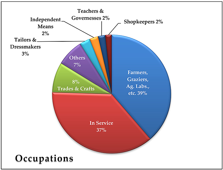
Gaddesby’s economy was primarily agricultural, both arable and dairy, although ancillary trades such as blacksmiths, carpenters and wheelwrights, butchers, shopkeepers, innkeepers, etc., provided the necessary services to sustain a rural community. During the early nineteenth century, several farmers and graziers – or more accurately, their wives and daughters – turned their hands to manufacturing Stilton cheese to supplement their income. Unmarried females mostly found work in service, many of whom were employed at Gaddesby Hall, the village’s chief residence. The Hall also provided men and boys with employment as grooms, butlers, valets, coachmen and gardeners.
At the time of Domesday, it is estimated around forty families were living in Gaddesby. The 1377 poll tax for Gaddesby records a population of around 177 (excluding children under the age of fourteen) whereas, by the middle of the nineteenth century, it had increased to almost 350. The late Victorian period saw a population decline, which slightly recovered in the early twentieth century (see Figure 3). Today, Gaddesby’s population stands around 450.

At the time of Domesday, Gaddesby consisted of approximately 1,365 acres of useful arable land and eighteen acres of meadow. During the medieval period, a three-field rotation system was used, with families allocated sellions in each field. The main crops were oats, barley and wheat. In the middle of the seventeenth century, almost 900 acres of land were enclosed. The 1847 tithe apportionment records a smidgen over 1,657 acres including copses and small woods. During the census years, Gaddesby’s acreage grew to 1,725 acres. The lower fields near the brook are particularly suited for grazing dairy cattle, and it was said the soil conditions there were partly responsible for my great-grandparent’s success at various agricultural shows (including first prize at London in 1905) for their Stilton cheese.

Although Gaddesby was originally a chapelry belonging to the manor and soke of Rothley, it had all the privileges of a mother church to perform sacraments and burials. Initially constructed in the twelfth century, the original chapel consisted of just a rectangular nave, possibly with a chancel and porch attached. Later additions included a north and south aisle and a tower. In the first half of the fourteenth century, two chantries were created at the western end of both aisles (enclosing the tower). Around the same time, oak seating was installed which survives today as some of England’s oldest wooden pews. The steeple was added later and the chancel (seen closest in Figure 5) was rebuilt in the fifteenth century. The church is dedicated to St Luke.
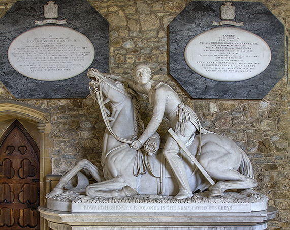
An unusual feature for a village church is the statue located in the chancel depicting the village’s celebrated Waterloo hero, Colonel Edward Hawkins Cheney, astride a wounded horse (see Figure 6), one of five horses shot from beneath the Colonel during the battle.
In 1837, a local Wesleyan preacher by the name of William Reeve persuaded Colonel Cheney (who resided at Gaddesby Hall) to sponsor the building of a chapel on Back Street and this became a second place of worship for many Gaddesby residents.
Sadly, the chapel no longer exists having been demolished in 1966. On the corner of Back Street (now called Chapel Lane) and Cross Street lies a large ‘blue stone’ upon which John Wesley (who spearheaded the Methodist movement) reputedly once preached a sermon.

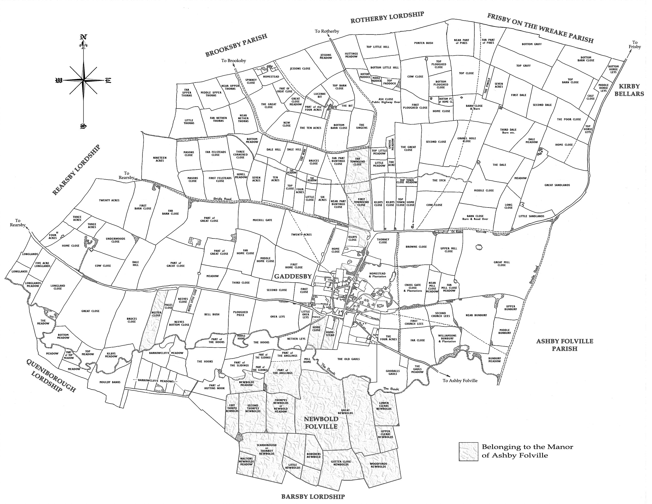
Much of the old village centred around a roughly rectangular area bounded on the west by Back Street (now known as Chapel Lane) and Main Street (sometimes called Front Street) on the east, the latter rising gently northwards to meet Park Hill close to its junction with Cross Street (see Figure 7 1). After passing to the north of the Cheney dower house (which then was part of the lordship of Ashby Folville), the road from Rearsby took a rectilinear route around the old Smithy, before passing by The Gate public house to join the road to Ashby Folville. Gaddesby Hall still stands in extensive grounds adjacent to St Luke’s church and following his father’s death in 1848, the Colonel’s son, Edward Henshaw Cheney, embarked on an ambitious project to re-landscape the area to improve the southern vista from the Hall. A new and much straighter road was built to link the two routes leading to Rearsby and Ashby Folville, which now runs to the south of the old dower house. The smithy, public house and the other buildings in the vicinity were all demolished and as a result, the old dower house was given over to replace the demolished inn which is now called The Cheney Arms. The smithy temporarily relocated to the wheelwrights’ workshop on Main Street before moving into purpose-built premises adjacent to the chapel on Back Street.
1 The map (the original is now in my possession) was drawn by my first cousin once removed, A. K. Baker (1918-2016), who was also born at Gaddesby. An aeronautical draughtsman by profession, Ken Baker was also a keen family historian who authored A Gaddesby Connection in 1995.

Colonel Edward Hawkins Cheney, C. B. was born into a distinguished military family, the eldest son of Robert and Bridgett Cheney of Meynall Langley in Derbyshire. He enlisted into the 2nd (Royal North British) Dragoons (The Scots Greys) at the age of thirteen as a cornet and was severely wounded at the siege of Nijmegen (1794-95). Promoted to Captain-Lieutenant in 1800, Edward was made a full Captain three years later. He married into the Ayre family who resided at Gaddesby Hall and made it his home. Following the Battle of Waterloo in 1815 – during which Edward Cheney was promoted on the battlefield by Wellington after becoming the regiment’s senior officer – the Colonel returned to Gaddesby to live with his wife, Eliza, their two children and his spinster sister-in-law, Mary Ayre, the hall’s matriarch. Sadly, a six-week-old Cheney son along with his mother passed away in 1818 leaving the Colonel with two motherless infants aged four and six years. Fortunately, some years earlier, a girl from nearby Pickwell named Ann Danzey was employed in the nursery to look after the Cheney children, one of whom was Edward Henshaw Cheney who would later remodel the village landscape. In that same tragic year, Ann Danzey married a local carpenter, John Smith. Although she would normally be expected to give up her duties at the Hall, the heartbreaking circumstances there compelled Ann to continue providing maternal comfort and support to her two Cheney charges for many years, despite raising seven surviving children of her own. John and Ann (née Danzey) Smith are my second great-grandparents.
From an analysis of Gaddesby’s census returns (1841-1921), coupled with entries in the 1939 register created on the eve of WWII, we find seven family names appear in all ten recordsets.

The earliest Gaddesby parish register entry for each of these surnames is as follows:3 UNDERWOOD (1570, burial), HARDY (1572, burial), SMITH (1574, marriage), WARD (1599, baptism), JOHNSON (1619, marriage), COX (1627, baptism) and WHAIT (1747, baptism).
Other long-standing Gaddesby families include BROWN (1593, baptism). The name appears in all nine census returns (with a total headcount of 149) but not the 1939 register – it may be redacted. Also, the name NEEDHAM (1599, burial) appears in eight of the ten recordsets (1871 and 1939 being the exceptions). Through a favourable sixteenth-century marriage, the Needham family gained possession of Paske Hall which they held for almost two centuries. Thomas (1631-1699), the son of John Smith of Cropwell Butler in Nottinghamshire, founded the country’s first provincial bank at Nottingham. At the time of his death, Thomas Smith, styled ‘of Nottingham and Gaddesby’, held 1,400 acres at Gaddesby which he left in his will to his son and namesake, Thomas Junior.
Also worth a mention (even though her stay at Gaddesby was brief) is Louie Burrows, who arrived in 1911 to take up the position of schoolmistress at the local school. Lodging with a well-respected village spinster, Miss Sarah Elizabeth Cox, at Wesley Cottage (built on Back Street by Gaddesby’s first Methodist minister, William Reeve, and used as a preaching house before the chapel was constructed), Miss Burrows was at the time the fiancé of the renowned author D. H. Lawrence. Frequent visits to my great-grandparent’s house on Cross Street (just around the corner!), resulted in my great-grandmother, Emma Ann Smith, and Miss Cox being mentioned in the many letters between Lawrence and Louie Burrows.
3 The earliest entry in Gaddesby’s parish registers dates to 1568.
The Society for One-Place Studies is a leading organisation dedicated to supporting One-Placers worldwide.
![]()
![]()
![]()
![]()
![]()