The Society for One-Place Studies is a leading organisation dedicated to supporting One-Placers worldwide.
![]()
![]()
![]()
![]()
![]()


Middlestown is one of a number of villages/hamlets in the township of Sitlington (formerly Shitlington). The others are Netherton, Overton and Midgeley. Shitlington, was a township in the ancient ecclesiastical parish of Thornhill. The village is located halfway between the city of Wakefield and the town of Huddersfield and three miles south east of Dewsbury. Middlestown and Overton are separated from Netherton and Midgley by the wooded valley of the Coxley Beck. The geology of the area comprises the Coal Measures of the South Yorkshire coalfield, sandstone and Millstone Grit. In medieval times, ironstone was got from the Tankersley seam that outcrops in Overton and Emroyd Common in Middlestown. The surrounding landscape is littered with old coal pits.
In 1841, Middlestown had a population of 897. Of these, 484 were male and 413 were female. This imbalance suggests that either a significant proportion of girls had left the village (to find work as servants elsewhere) or that single men had migrated to the village to work in the local coal mines. Study of the Census returns confirms that numerous single men and boys were indeed living as lodgers throughout the village. This imbalance decreased over the succeeding decades:

In the later decades of the century, there was much new building and the population began to grow rapidly.

There are traces of early mining activity all over the landscape, but the early coal pits were of purely local importance. Transport problems prevented the export of any surplus to other parts of the country, for until the late eighteenth century, when improved roads and canals reached the area, the pack horse was the main means of conveyance for heavy goods. Until the technical innovations of the eighteenth century the demand for coal was small, and there was no incentive for inland pits like those of West Yorkshire to develop markets in other parts of England.
Two developments which stimulated demand were made in the early eighteenth century. One was the discovery that iron could be smelted using coal rather than charcoal, the second was the invention of a workable steam engine. The first recorded use of a Newcomen engine in Yorkshire was in 1714 and during the next fifty years many Yorkshire collieries installed them. The new pumping engines made it possible to cope with the problem of drainage in deep mines and so to extend the area in which coal could be worked.
The nearest colliery was Emroyd Colliery, just half a mile north of the town. There were two short-lived collieries just to the north of Smithy Brook: New Delight and Edge End. New Delight (aka Hostingley Pit) was close to the canal and linked to it by an inclined plane railway. Edge End Colliery was linked by road to coke ovens at Smithy Brook. The processed material was transported from Smithy Brook via another small industrial railway line which linked up with the canal at Horbury Bridge. Both Edge End and New Delight are shown as disused on the 1892/3 O.S. map.

James Milnes leased coal at Emroyd Common in the north of Middlestown not far from the Smithy Brook from Sir George Armitage of Kirklees Park in 1796. Here Milnes developed Emroyd Colliery. His 31-year lease included the right to make railways. He leased the ironstone rights for 29 years in 1798, and a year later he leased the land at Emroyd until 1827. A plan from 1801 shows nine ironstone pits and a furnace. Despite being well run, the company suffered from not having a connection to the growing railway network. The Leeds and Manchester Railway opened through Horbury Bridge in the 1840 but was separated from the waggonway by the River Calder and navigation. Production declined towards the 1880s and Emroyd was nearly worked out. The company asked the Lancashire and Yorkshire railway to provide a connection to the line through Horbury, but circumstances conspired to prevent it.
The 1841 Census enables us to see for the first time how much the local economy was dominated by coal mining. The Census of that year records for the first time the occupations of everyone (including children) who was in employment. The most numerous were: coal miner (103), labourer (87), hurrier (48), farmer (15) and servant (15).
A ‘hurrier’ was a young boy or girl employed in a coal mine to drag baskets or small wagons full of coal from the coal face where it was mined, up to the surface. Some of them were as young as five or six. The data in the table below were extracted from the 1841 Census.

Not surprisingly, many of the hurriers were the children of miners. Eight of them were living away from the family home.
The Mines and Collieries Bill of 1842 made it illegal for all females and boys under ten to work underground in coal mines, but many of the colliery owners ignored the new legislation. By 1861, the number of hurriers in Middlestown had dropped to eighteen and they were all male and over nine years of age.
If we look just at the heads of household, this is the full list of occupations in 1841:
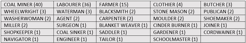
The presence of four clothiers in the village suggests that hand-loom weaving was still being carried out, though it was obviously a part-time occupation, since only one weaver is listed.
Coal mining still dominated the economy in 1861. 50% of households had someone who worked at the mines. The Jarvis family’s Albion Foundry on the outskirts of the town provided an alternative for the men. Christopher Mitchell’s worsted factory employed a number of the girls and women.
Fifteen farmers are listed in the 1861 Census. Three of them had additional occupations. The farms ranged in size from 5 acres to 61 acres, with the average being 26 acres.

Two labourers were employed at the largest farm, but on the rest there was only one. Most of the labourers listed in the Census were employed at the mines, with some also working on the roads.
The Calder & Hebble Navigation, opened in 1769, passes to the North-East of Middlestown.
The Wakefield and Austerlands Turnpike, constructed in 1758, passes through the centre of the village (where it is known as Old Road).
A second turnpike road, built in the 1830s and known as New Road, runs north from Middlestown through Thornhill to Dewsbury.
As noted above, there was significant migration of young men into the village during the first half of the nineteenth century. Here are some examples from the 1861 Census:

Only one of them (Thomas Wood) was there in 1871. Edwin Sykes became a railway labourer in Slaithwaite. Reuben Fletcher moved to Leeds, but continued as a coal miner. Henry Lister became a house painter in Rastrick. George Lister became a sawyer in Bowling.
The Armitages had purchased the manor of Middle Shitlington in 1598 and remained one of the major landowners for at least the next three hundred years.
Baines’ Directory and Gazetteer of 1822 lists the following:

Kelly’s Directory of 1881 lists the following:

The principal landowners in 1881 are recorded as Wentworth B. Beaumont esq, George L. Fox esq, Captain Henry Savile and Sir George Armitage bart.
Surnames that persisted through the whole period from 1841 to 1891 are:
Adamson, Armitage, Balmforth, Beatson, Bedford, Blakeley, Bowers, Brook, Clegg, Dunford, Field, Fox, Hampshire, Hargreaves, Healey, Hickling, Ingham, Jarvis, Johnson, Kaye, Lister, Lumb, Matthews, Moates, Preston, Ramsden, Ripley, Scargill, Smith, Taylor, Walker, Westwood, Wood.
The Society for One-Place Studies is a leading organisation dedicated to supporting One-Placers worldwide.
![]()
![]()
![]()
![]()
![]()