Website: my-ops.wikidot.com/
Contact: Steve Terry
Overview

The purpose of this study is to explore the changes that took place in the parish during the nineteenth century.

Geography
Modern map of Mirfield

The parish of Mirfield straddles the River Calder three miles west of Dewsbury. It is bounded on the North by the parish of Birstal, to the South by the parishes of Thornhill and Kirkheaton, to the East by Dewsbury, and to the West by the Parochial Chapelry of Hartshead.
Rev Ismay, writing in 1755, says that Mirfield is divided into six hamlets: Towngate, Lee Green, Northorpe, Easthorpe, Far Side Moor and Hopton. Hopton still retains its own identity, but the others are now very much part of the town of Mirfield.

Population

In 1755, the population was little more than 2,000. It steadily grew over the next century, but then there was a dramatic increase to a maximum of over 16,000 in 1891.

Population change in Mirfield

The village of Ravensthorpe did not exist until the middle of the 19th century when large numbers of houses were constructed alongside the new textile mills. This is the explanation for the dramatic rise in population during the second half of the nineteenth century.

If we break the parish down into its seventeen Census enumeration districts, we find that females considerably outnumbered males in almost every district. There appear to be two possible causes.

• Females have migrated into Mirfield for work.

• Males have migrated out of Mirfield for work.

There appears to have been plenty of work for unskilled males in the coal mines, in the woollen mills and as agricultural labourers, so the first explanation seems the more probable.

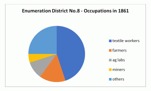
If we take Enumeration District no. 11 as a typical example, thirty-seven women (24%) were in employment. Twenty-three of these worked in the textile industry and nine were in service.

By contrast, in Enumeration District No. 14 (where males were the dominant sex), of the sixteen women (14%) who were in employment, ten worked in the textile industry, none worked as servants. 

History

Following the Norman Conquest, Mirfield and Hopton were among 214 manors, mainly in Yorkshire, that were given to Ilbert de Lacy. Ilbert is thought to have fortified his manor at Mirfield with a motte and bailey. The mound still survives beside the parish church.

In the 14th century, Mirfield was a flourishing centre of the woollen industry and already a place of some agricultural and industrial importance. In 1378, the Poll Tax in Mirfield was 59 shillings, whilst in Huddersfield it was only 19 shillings and four pence and in Halifax 12 shillings and eight pence.

Mirfield was devastated by the plague in the 1630s.

In January 1642, the Civil War came near to the locality when Sir Thomas Fairfax wrote to the Constable of Mirfield ordering “all that be of able bodyes from the age of 16 to 60 to repair to Almondbury on Saturday with all weapons they can procure and provisions for five days” to assist “in driving out the Papist army,” The Constable was warned “to fail not at your peril”.

When Bonnie Prince Charlie and his army were marching to Derby in 1745, he produced something like mass-panic in Mirfield. Fearful that the Scots were going to sack the town, men and women hurried with personal belongings and food which they hid in local coal workings.

In 1775 the Reverend Joseph Ismay describes Mirfield thus: “This is a large populous village and, in general, is well built. It is divided into six hamlets, and contains about 8,000 acres of land, viz: 2,000 of arable, 400 of waste or common, and 600 of woodland. The number of houses are about 406. There are three corn mills here, and the same number for pulling of broad cloth, which is manufactured here and in neighbouring towns.. Sir George Savile, of Rufford, Notts., Bart., is Lord of the Manor. There is a fair or feast on Ascension Day, held near the Vicarage”.

Economy

In 1755, the Rev Ismay recorded that “no less than 600 persons are employed in the woollen manufacture: 200 in making of cloth and 400 others engaged in carding, spinning, and other kindred occupations”.

Baines’s directory of 1822 gives a good indication of the economic life of the town:

There was also a bank run by Benjamin Wilson and Son, three coal owners and three mill owners.

Pigot & Co’s directory of 1841 shows a significant increase in numbers in certain sectors, particularly shopkeepers:

The woollen industry continued to dominate in the decades that followed. For the 1861 Census, Mirfield was divided into seventeen enumeration districts, each with its own unique combination of craftsmen, tradesmen, farmers and labourers. Here are a couple of examples:

Occupations 1861 District no. 8
Occupations 1861 District no. 9

In the 1850s it was decided to establish a new community on empty land between Mirfield and Dewsbury. The community was named Newtown and quickly acquired its first woollen mills (specialising in blankets and carpets). Large numbers of houses were constructed alongside the mills. A large gas works was built in 1857. In 1861, two-thirds of family heads worked in the woollen mills – there was no other choice for unskilled labourers. It was later renamed Ravensthorpe.

The transition from handloom weaving, which had been carried on for centuries, to powerloom weaving did not occur without incident. There seems little doubt that Mirfield men were among the Luddites who gathered near the Three Nuns Inn one night in 1812. They marched across the fields and attacked Rawfolds Mill in Cleckheaton where the new looms had been installed. The military had been warned, the raid failed and numbers of Luddites were hanged at York.

Worship

Anglican

The first parish church at Mirfield is believed to have been built in the late 13th century; until that time residents of Mirfield had to travel to Dewsbury to worship. By 1826, the parish had a population of more than 5,000 souls and the medieval church was too small for a growing industrial town, so the body of the church was demolished and rebuilt. This second church did not last until even the end of the century, because in 1865, money began to be raised for its replacement. The new church, constructed on a far larger scale than either of the previous two churches, was consecrated on 12 October 1871. The old church was demolished, save for the tower, in 1873.

Christ Church (Battyeford) was built c.1840 and destroyed by fire in 1971. St. John’s (Hopton) was consecrated in 1846, St. Peter’s (Knowl) in 1874, and St. Paul’s (Eastthorpe) in 1881. The Church of St Saviour was built at Ravensthorpe in 1864 but was replaced in 1901 by a large Gothic revival church.

Others

The Moravians, Baptists, Independents, Swedenborgians, Wesleyans, New Connexion and Primitive Methodists had chapels in various parts of the parish. Most had schools attached.

The Moravians built their first church in the town in 1751.

John Wesley opened Mirfield’s first Methodist Church at Knowl in 1780.

In 1816, the first Baptist meetings were held in Mirfield, in the old Tythe Barn in Towngate, and the first Baptist Church was opened in 1830.

A New Congregational Church was built at Ravensthorpe in 1870.

Institutions

Nine pubs are listed in the 1822 directory: Beaumont’s Arms, Original Three Nuns, Three Nuns, Black Bull (an old coaching inn), Horse Shoes, Dusty Miller, Ring of Bells, King’s Head and The Swan. By 1841, the Ring of Bells has disappeared, but eleven have been added: the Bull’s Head, Flower Pot, Fountain, Mason’s Arms, Nelson, Robin Hood, Shepley Arms, Ship, Shoulder of Mutton, Wilson’s Arms and Yew Tree. By 1853, two more have appeared: the Airedale Heifer and the Railway Inn.

Educationally, Mirfield comes into the picture in 1667 when Richard Thorpe, a local parson of independent means, endowed a free school “for teaching fifteen poor children of the inhabitants of the parish till they can read English well”. This foundation later became Mirfield Grammar School (now The Mirfield Free Grammar).
Wellhouse Academy was a Moravian Institution established in 1801. In 1851 the director was John Lang (38). He was also the minister of the Moravian chapel.

A boarding school for young gentlemen is recorded in an 1822 directory.

Roe Head, a former training college and now home to Holly Bank School for youngsters with physical and learning difficulties, opened in 1830 as a school for refined young ladies. It had strong connections with the Brontes and was run by Margaret Wooler and three of her five sisters. Elizabeth Gaskell (The Life of Charlotte Bronte) describes Margaret Wooler as “kind, motherly” and “a native of the district”. In 1831 Charlotte Bronte arrived and later became a teacher there [1835-38], her sisters Emily [1835] and Anne [1836-37] were pupils there. By 1861 it had reverted to being a private residence.
An 1841 directory lists a Free School at The Knowl, two schools at Towngate, one of which was a National School, a Moravian school and three others, one of which was a boarding school.

An 1870 directory says ‘Over Hall, a neat old building, surrounded by shrubs and plantations, and healthily situated, is now a boarding school’. It was run by George Kent with the help of four governesses. The seventeen pupils (girls aged eleven to nineteen) were mainly from Yorkshire, but included two from Manchester and one from Durham.

The Reformatory at Hopton was established in 1855 and had a farm of 60 acres attached. It housed around a hundred young criminals, all teenage boys, mainly from Yorkshire, but a few from further afield.

A parliamentary report of 1777 mentions a workhouse in operation for up to 30 inmates. It was located on Crossley Lane. The Governor was paid £12 12s per year. Around 1834, a second workhouse was established at Knowl. All road repairs in the area were carried out by paupers from the workhouse.
The 1841 directory lists a Mechanics’ Institute, located at Bracken Hill.

Travel

The Dewsbury & Elland Turnpike was built around 1763 and passes through the centre of the parish. The Birstal & Huddersfield Turnpike was built a couple of years later and passes through the north-west corner of the parish. Good links to Dewsbury and Huddersfield have probably always been important to the economic life of Mirfield.
The canal (its official title was the Calder & Hebble Navigation) opened in 1766. The railway which reached the town in 1848 brought additional employment as well as advancing commercial prosperity.

Freight trains on the Calder Valley main line near Mirfield (geograph-2151140-by-Ben-Brooksbank)

All the communities that bordered on the river had at least one ‘waterman’ who could be hired to row you across.

Battyford Ferry Boat
Migration

We have already seen that migration of girls and young women into the parish is a likely cause of an imbalance between the sexes. The mill owners employed plenty of women in their mills, but also in their homes as servants. The colliery owners also kept plenty of servants.

Migration into the parish of Mirfield has been explored further by looking at the birthplaces of heads of families in the 1861 Census.

Birthplaces 1861 District no.17
Birthplaces 1861 District no.9


Enumeration district No. 17 is basically the village of Hopton. It seems that its links with Kirkheaton, its neighbour to the south, were as strong as those with Mirfield.

Not surprisingly, most of the migrants from outside Yorkshire came from Lancashire. The other major contributors were Northumberland, Lincolnshire, Derbyshire and Durham.

The people who settled in the new town of Newtown (later Ravensthorpe), came primarily from the neighbouring towns of Dewsbury, Batley and Ossett. One notable exception was a young man who came from Witney in Oxfordshire, another centre of blanket making. In 1861, only 11% of family heads were born in Mirfield.

Families & Notable People

A study of the Mirfield baptismal registers was carried out to discover the most common surnames. For the period 1559-1669, they were:
Hepworth, Walker, Hirst, Brook, Sheard, Ledgard, Sonyer, Lee, Rhodes and Holdsworth.
For 1776-1795, they were:
Sheard, Brook, Hirst, Ledgard, Ellis, Walker, Hepworth, Scholefield, Barker and France.
A directory of 1822 provides a list of the local gentry. Excluding the clergy, they are: Samuel & Edward Brook, Thomas Brown, Margaret & Martha Ingham, John Ledgard and Richard Shepley.
An 1835 Poll Book lists 118 individuals. The most common surnames are Armitage, Brook, Crowther, Ellis, Haigh, Hebblethwaite, Holdsworth, Jackson, Lee, Sheard, Stancliffe, Walker and Wheatley.
BROOK
The 1841 Census shows three families living in adjacent houses at Westcliff: Mary, a widow with five children; Hannah, a widow with two children and four servants; Samuel and Edward in the third house.
INGHAM
By 1851, the major landowner in Mirfield, with an estate of 220 acres, was Joshua Ingham J.P. of Blake Hall. He employed 40 farm labourers, but obviously had interests elsewhere – the Census records that he also employed 13 artisans, 100 colliers, 100 hurriers, 100 millworkers (at Pit Mill) and 10 pickers. He had a domestic staff of eleven, plus a butler (who had his own cottage). Anne Bronte worked for the Inghams as a governess for eight months in 1839. Her first novel, Agnes Grey, was based on her time at Blake Hall.
STANCLIFFE
In 1851, John Stancliffe (51) was living at Over Hall with his wife, two children and two servants. The building also housed a girls’ boarding school. John had several moneymaking ventures: he was a coal proprietor (employing 13 men and 12 boys), a maltster (employing 4 men) and a farmer of 62 acres (employing 4 men).
ARMITAGE
In 1851, William Armitage (44) was living at Castle Hall, adjacent to the parish church. He was a farmer of 100 acres and also a land surveyor.
LEDGARD
The Ledgards appear to have invested their money in property. The 1851 Census records Hannah Ledgard (46 and a widow) as a proprietor of houses.
WHEATLEY
In 1841, Thomas and Mary Wheatley were living at Cote Walls with two of their children and five servants.
The 1861 Census records five Wheatley families living in close proximity to each other:
Joshua (60) was a woollen merchant, Richard (52) was a farmer of 97 acres, Henry (50) was a cloth merchant, Charles (48) was a farmer, coal proprietor and magistrate and Edward (41) was also a magistrate.
They are probably descended from John Wheatley, a clothier, who seems to have moved into the parish c.1775. 

Resources

Diary of Rev. Joseph Ismay, Vicar of Mirfield from 1735 to 1778

O.S. maps

Census returns

Trade directories

1835 Poll Book

Parish registers

www.visionofbritain.org.uk

www.histpop.org

www.genuki.org.uk

www.mirfieldmemories.co.uk

http://mirfield-2ndlook.info

Frances Stott, Looking Back At Mirfield, 2000

Harold Norman Pobjoy, A History of Mirfield, 1969

Joseph H. Hird, Yorkshire Folk in the Early 1900s: my childhood in Mirfield, 2014

Marie Hartley & Joan Ingleby, Life and Tradition in West Yorkshire, 1990

Fred Singleton, Industrial Revolution in Yorkshire, 1970

The author of this work retains all rights and must be credited when the material is displayed or shared. Any use of the material for commercial purposes requires the written consent of the author, as does any use of a significant portion of the material for purposes other than individual private research.

The Society for One-Place Studies is a leading organisation dedicated to supporting One-Placers worldwide. 

Facebook Page  Twitter Profile  Instagram  YouTube  Members only Facebook Group  Pinterest

Contact Us

By email:
info@one-place-studies.org

By post:
Society for One-Place Studies,
28 St Ronan’s Avenue,
Southsea, Hampshire, PO4 0QE
United Kingdom

© The Society for One-Place Studies